arcmap创建空间索引_NetCDF数据在ArcMap中的使用
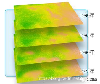
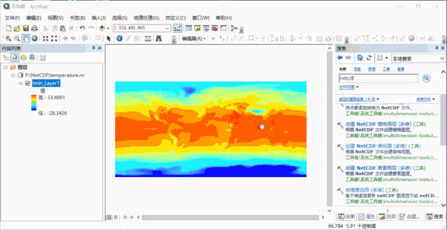
NetCDF又称科学数据集,可以存储温度、湿度、风速、风向等多个维度的文件格式。1、在ArcMap中显示NetCDF数据ArcMap不能直接读取NetCDF数据,需要使用GP工具Make NetCDF Raster Layer(创建NetCDF栅格图层),将NetCDF生成栅格图层。2、显示特定年份的温度图层方式一:直接在图层属性中设置。方式二:使用GP工具Select by Dimen...
NetCDF又称科学数据集,可以存储温度、湿度、风速、风向等多个维度的文件格式。
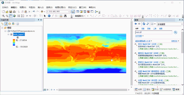
1、在ArcMap中显示NetCDF数据
ArcMap不能直接读取NetCDF数据,需要使用GP工具Make NetCDF Raster Layer(创建NetCDF栅格图层),将NetCDF生成栅格图层。
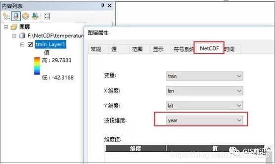
2、显示特定年份的温度图层
方式一:直接在图层属性中设置。
方式二:使用GP工具Select by Dimention(按维度选择)。
3、按照时间动态展示数据
首先对图层启用时间,然后打开时间滑块。
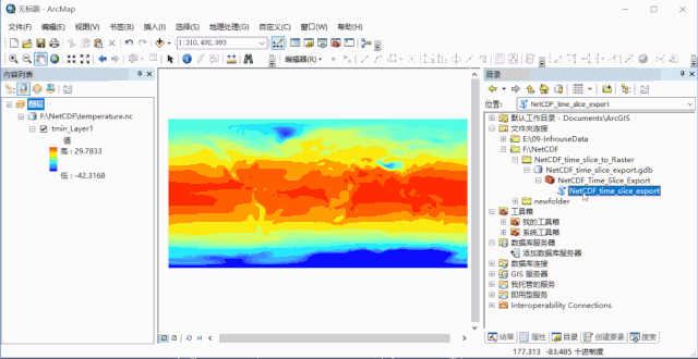
4、按照年份,导出NetCDF的每幅栅格
1)设置NetCDF图层的波段维度为Year。
2)复制这里→(https://pan.baidu.com/s/1acJB6v9RqyMqmWuqVENzwA?errno=0&errmsg=Auth%20Login%20Sucess&&bduss=&ssnerror=0&traceid=#list/path=%2F)下载,NetCDF_time_slice_to_Raster.zip,解压后,添加到目录窗口中,然后运行工具。
生成结果是以Band_命名的。我们可以稍微改下代码,以年份命名。打开脚本方法如下:
修改后的脚本如下:
-
# -------------------------------------------------------------------
-
# export_netCDF_slice.py
-
# Created on: 2011-06-02 10:18:49.00000
-
# Description: This scipt will create a TIFF raster from a NetCDF layer, and
-
# save each band of that TIFF as a seperate TIF raster (for each time slcie in a netcdf file)
-
# -------------------------------------------------------------------
-
# Import modules
-
import arcpy, os
-
#Inputs
-
Input_NetCDF_layer = arcpy.GetParameterAsText(0)
-
Output_Folder = arcpy.GetParameterAsText(1)
-
Input_Name = Input_NetCDF_layer
-
Output_Raster = Output_Folder + os.sep + "NetCDF_Raster.tif"
-
#Copy the NetCDF layer as a TIF file.
-
arcpy.CopyRaster_management(Input_Name, Output_Raster)
-
arcpy.AddMessage(Output_Raster + " " + "created from NetCDF layer")
-
#Reading number of band information from saved TIF
-
bandcount = arcpy.GetRasterProperties_management (Output_Raster, "BANDCOUNT")
-
resultValue = bandcount.getOutput(0)
-
count = 1
-
# Year
-
yearN = 1875
-
arcpy.AddMessage("Exporting individual bands from" + Output_Raster)
-
#Loop through the bands and copy bands as a seperate TIF file.
-
while count <= int(resultValue):
-
Input_Raster_Name = Output_Raster + os.sep+ "Band_" + str(count)
-
Output_Band = Output_Folder + os.sep + str(yearN) +".tif"
-
arcpy.CopyRaster_management(Input_Raster_Name, Output_Band)
-
arcpy.AddMessage("Band_" + str(count) +".tif" + " " "exported" + " " + "successfully")
-
yearN +=5
-
count +=1
-
# The following will delete the TIFF file that was created by CopyRaster tool.
-
arcpy.Delete_management(Output_Raster,"#")
-
arcpy.AddMessage("Tool Executed Successfully")
- END -
ArcGIS数据生产与精细化制图之中国年降水量分布图的制作(附练习数据)ArcGIS desktop——“热力图”实现方法比较超级详细ArcGIS入门讲解和土地确权操作流程培训教程【收藏】7.72GB ARCGIS ERDAS ENVI干货教程网盘下载ArcGIS实战教程:空间统计分析,冷点热点分析

DAMO开发者矩阵,由阿里巴巴达摩院和中国互联网协会联合发起,致力于探讨最前沿的技术趋势与应用成果,搭建高质量的交流与分享平台,推动技术创新与产业应用链接,围绕“人工智能与新型计算”构建开放共享的开发者生态。
更多推荐

 0
0 0
0- 0


 已为社区贡献2条内容

所有评论(0)